Saturday, August 21, 2010

Leg #13 London City to Lydd


One of the shortest legs of the T&E series, the flight from London City Airport to Lydd was 46 nautical miles. I refueled at City of Lights FBO with 37.03 gallons at $3.80/gallon. The departure out of EGLC was as dramatic as they get with a skyline in the foreground at what seems just off the end of the runway - metropolis obstructo-terribilis if I've ever seen one.


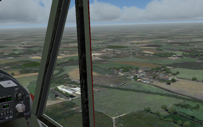
The weather was decent and kept things cool at low altitude as I stayed below with a few clouds at 1500 and a broken layer very close to above that. Along the way there were miles of quaint hamlets and small farming communities, I presumed.


I flew low and slow , following M20 to Dover and then turned west and followed the English Channel to Lydd. After landing, I went ahead and refueled with the good folks of GrowlAir-UK, purchasing 7.29 gallons of 100LL for only $3.50 gallon.

Stats: 0h 54m; 46 NM; 7.29 gallons of fuel (8.1 gal./h) Next flight is across the channel to the Netherlands. I'm really looking forward to my adventure through Europe.

Friday, August 20, 2010

Leg #12 Stornoway to London City

My first night flight was on this leg, 458 nautical miles from the outer Hebrides, Isle of Lewis to Great Britain, and the big bustling return to civilization: London! My decision to fly entirely through the night was partly because I could - should I have had any difficulties there were plenty of airports along the way, but the other reason was I was worried about a low pressure system getting too organized and heading inland.


First step was to refuel at BAI Flight Group in Stornoway (bought 48.420 gallons of 100LL at $3.40/gallon) which had good service and pretty good prices for way out here I thought). I did have about an hour of light and then 30 minutes of twilight, and then the moon was slightly in my favor.


The rest of the trip was pretty much uneventful, but darker than I had expected as I crossed over large swatches of darkness across Scotland. The first glimmers of light from London made up for all of that though as after hours of flying the city's lights looked like jewels.


My plan was to look for the Thames and then follow the river to London City Airport. All of that was easy enough but landing at night at EGLC, with it's notorious crosswinds and metropolitan hazards was a bit trying after five hours in the cockpit of Six-Five-Mike.


After landing I rolled to a stop and then taxied over to London City Airport Jet Centre to let them know I was tying down for the night and where was the closest pub, which was Royal Standard, though it was not recommended. Instead they suggested the Royal Oak, which turned out to be rather a sparse affair, but they at least served me Young's Bitter and that was quite decent indeed. Total miles for the day: 459. Total time: 4h 57m. Fuel used: about 37 gallons. Average speed: 92.7 knots. Average fuel usage: 7.5 gallons per hour.

Wednesday, August 18, 2010

Leg #11 Reykjavik to Stornoway


Departure weather in Iceland this morning was pretty good, though there were plenty fo clouds along the way. BIRK METAR showed winds 340 at 4 knots, unlimited visibility, except for a few clouds at 3500 feet, and scattered layers above at 5600 feet. Today's leg was 573 nautical miles across the lonely North Atlantic. Actually it wasn't that lonely, because I was able to tune into the HF bands and listen to the airliners overhead check in with long reports - apparently they do this every 300 miles or so...which is about every 45 minutes for those big jets.


Because there would be very few landmarks (in fact none over water), my plan for the day was pretty much as with the previous leg fly a rhumbline course corrected for average magnetic declination. A look at the winds aloft forecasts showed I would be flying into, or actually across an area of low pressure. The winds would be blowing one way for part of the flight, and would be changing directions throughout.


So I hoped for the best and forged on without making any corrections for wind. After refueling at Iceland Combined Air Operations FBO (48.136 gallons of 100LL for only $3.60/gallon), I received a weather report for the Hebrides - Stornoway reporting winds 310 at 10 knots, clear skies, few clouds at 2600 feet. Sounds like lovely weather and I would need it since my arrival would be after sunset. I cranked up Six-Five-Mike, taxied to Runway 13 and took off. The view of Iceland as I climbed to 7500 feet was pretty nice.


The rest of flight was bumpy at times but nevertheless quite pleasant and there's wasn't much to do but drink coffee above the lull of the purring engine, and imagine where the heavies were when they checked in at ALDAN, ATSIX, and GONUT (my favorite!).


As the evening wore on and the sun set, nighfall and clouds were my only companions. The faint ident of STN VOR awoke in me once again a sense of civilization. The winds had died down a little but not enough to compell me to sideslip a little on final just to shake off the rustiness of the long overwater flight. And after landing I realized then that I had done it - I had flown across the Atlantic in a single-engine Piper Cub. I have many more miles to go, but if I stopped now at least I'd know this accomplishment.

The final tally for the day was 573 nautical miles in 5 hours 19 minutes. I burned on average 9.02 gallons per hour and averaged 108 knots ground speed today, not bad.

Monday, August 16, 2010

Leg #10 Narsarsuaq to Reykjavik


Departed the southwest coast of Greenland this morning at 1136 local and flew in and out of clouds all day long, just maintaining a rhumbline course corrected for average magnetic declination: final heading 097 magnetic. That was basically my flight plan - that and fly at an altitude of 11500 feet MSL all afternoon and evening.

After reaching altitude noted a airspeed was 90 MPH (about 78 knots), and with the engine humming along nicely at 2200 RPM I was only burning 6 GPH by the meter. Looking down i could see nothing but icy blue water, and ahead of me nothing but cluds, mostly with tops a few thousand feet below. Six hours later I started to pick up Keflavik VOR. It was bearing 125, but i could not tell how far away it was becuase my DME only goes to 99.9 NM and that's what it showed and that's what it always shows whenever the distance is 99.9 NM or greater. So I had to wait. Fortunately it was not too long. A few minutes later the DME started ticking down and I turned toward the VOR but there were lots of clouds. About an half hour later I noticed the plane was being blown off course with winds from the southwest.

At 8:19 PM Iceland local time I noted 35 NM from KIF VOR and I started down. AT 8:26 I started picking up the NS NDB slightly left of the nose. I made that turn direct now and noted lower winds. A few minutes later I was able to make out the Reykjavik ATIS, which reported information Tango winds from 182 at 5 knots, visibility 17 miles in light rain (must be pretty light), few clouds iin layers from 800 to 1800, and a broken layer at 5000, landing and departing runway 19.

It's 8:33PM and Land ho: Keflavik off the right wing. 11 minutes later the airport was in sight and five minutes later I landed on runway 13 and taxied to a grassy area next to a large hangar out of the wind.

Distance: 668 NM
Time: 7 hours 13 minutes.
Average speed: 92.6 KTS
Fuel Used: 48 gallons (6.65 gallons per hour)

Saturday, February 27, 2010

Leg #9 Goose Bay to Narsasuaq

The flight from Goose Bay was the longest leg, yet. At 674 nautical miles it took 9 hours and 8 minutes from Canada to Greenland. First sight of land put me well south of Narsasuaq, which was a bit disconcerting. I was also a tad low on fuel and worried about how much is actually usable in the Super Cruiser. I had a little extra in a 2-gallon emergency plastic gas can. I found a smooth patch of semi-grassy yet mostly-gravelly bit of terrain near a small, long lake and set her down. After I added the extra gas I took a little nap. When I woke up the winds had picked up a little, and there was a fine dust all over me and the plane. It was sort of grey-green and almost seemed volcanic, but soft at the same time. The last little bit to Narsasuaq was, thankfully, only 25 minutes of flying.

Friday, February 26, 2010

Leg #8 Presque Isle to Goose Bay

LEG 8 - PRESQUE ISLE TO GOOSE BAY

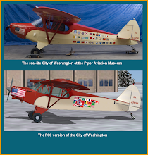
This so far was the longest leg of the journey, but there are longer leg, yet - so at 1930Z I checked the weather in northern Maine (yep it's still cold as heck), loaded 50 gallons of the good stuff at New England Flight Support, Crown of Maine Office, taxied The City of Washington out to Runway 1, and was airborne by 2017Z. This would be a long flight and over some fairly barren landscape, so I decided to fly a bit higher than usual and leveled off at 7500 MSL on amagnetic rhumbline of 057.

Lucky me the autopilot wasn't acting up and we hummed along nicely for almost four hours before I noticed a gradual change in the terrain. Looking at the sectional it seemed to me that I was a bit west of course, veering closer to Churchill Falls than Goose Bay, which was confirmed with the ADF pointing out that the Churchill Falls NDB was over that-a-way. A few minutes later the Wabush VOR started ditting and dahing, and within a few minutes I had a fix: 68 miles west of planned track after 366 nm. Well there's still plenty of time and enough fuel, so using the 1-in-60 rule of thumb I calculated a new course of 097 to Goose Bay, turned on course, tuned in to the Goose Bay VOR and waited. Here, from my log:

0000Z - waiting

0005Z - waiting, wondering if I should make extra correction for winds - nah - I'm pretty close.

0030Z - waiting, wondering if I should have made a correction for winds on this leg. Skies clearing. 2300 RPM.

0100Z - I ought to be getting closer - it's been about an hour...waiting for VOR or NDB indicators. I wonder if I should have made a correction for wind on this leg.

This went on some time, as I monitored the engines and autopilot, until:

"da da dit da, da da dit da, dit da dit" - the VOR! the VOR! Yay!

0111Z - picked up Goose Bay on 117.3. Heading of 100 is very close to calculated 1-in-60 heading of 097.

0138Z - picked up the Goose Bay NDB on 257 KHz.

ATIS indicates calm winds, RWY 8 in use - bonus! Arrived at 0220Z, and tied down at Avalon Flight Center - Labrador. 3 gallons of fuel remaining.


-

For more on how to make enroute track error adjusments, see: here

Sunday, January 31, 2010

Leg #7 Teterboro to Presque Isle

With a consecutive day of good weather I decided to launch for Presque Isle, Maine this afternoon. This leg was a tad longer (436 NM) than what I've done lately and of course sans GPS, but the scenery was great, and there were enough characteristic landmarks to help me verify my course. It was also an important point of arrival for this trip because it was here that Truman & Evans began their historic journey.

The magnetic rhumbline heading is 052, but the corrected heading with forecasted winds at 6000 (I would be flying at 7500) was 042. I left at 12:33 PM, climbed to 7500 and set my heading and waited for the first landmarks - everything looked good after 30 nm. Three hours later I discovered I was over Bethel, ME - I though I am glad to be here, but am about 9 NM west of course. The winds aloft must have been lighter than anticipated. I decided to maintain my course as the scenery was great and the rugged terrain of the Presidential Range Wilderness Area passed under my left wing, with lots of fingerling lakes to the east.

At 4:31 PM I picked up the Presque Isle VOR; it was about 23 degrees right of my current course and about 62 NM away. So I was still just a few miles left of course, maybe a tad more, but within reason. I homed in toward the VOR, making wind corrections as necessary until I saw the airport, and then turned into a long shallow base leg, and then final, and finally landed RWY 1, with only a slightly moderate left crosswind after 4 hours and 29 minutes of flight time. Fuel burn: 35 gallons (7.8 gallons (and $29.50) per hour).