Thursday, July 21, 2011

Leg #17 Paris to Marseilles


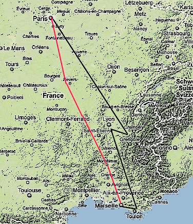
Not my best day of navigation, yet it turned out my navaid references were sorely out of date. The red line my intended route and the black my actual. I knew that I was no longer in Kansas when I saw the rising terrain. Fortunately I was able to pick up the Lyon VOR as the sun was setting, which gave me a chance to see some of the French Alps.


Finished the flight at Marseilles after logging 5:52 minutes in the cockpit and burned about 44 gallons of fuel!

Wednesday, July 20, 2011

Leg #16 Brussels to Paris


On to Paris! Started the day in Brussels with a southwest departure at 1411Z under broken layers at 1600 and 4000 feet. As I left EBBR I could see jets departing the airport and turn to the south. The clouds thinned out a little enroute and I managed to level off at 2500 feet. My course strategy was simple, just as in other legs, just tune in the destination VOR, fly a rhumbline direct, and then follow the closest radial all the way in.


After about 15 minutes I encountered a light rain, which was intermittent for the next half hour. The ceeiling was higher now. After about an hour the ride became a little bumpy as I flew over the Parc naturel Regional de l'Avenois.


LFPG ATIS indicated they were landing west, and when I called tower I was told to enter a right base for runway 27Rm, and then after an Airbus went missed I was cleared to land. Burned 77 gallons of fuel. Flight time was 1 hour 32 minutes.