
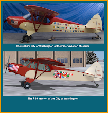
On August 9, 1947, Evans in the "City of Washington" and Truman in the companion ship, "City of the Angels," left Teterboro, New Jersey and flew 25,162 miles around the world. They returned to Teterboro on December 10, 1947 with Truman landing first. One of the unique things they did along the way to have flags painted on the left side of the fuselage, representing the countries at where they landed.
Using Microsoft Flight Simulator (FS2004), I plan to fly all 55 legs that Truman and Evans flew, in real time, and with real weather. The only exception is for airports that no longer exist; some were military airports that are now subdivisions! And for them I plan to fly to nearby airports in those special cases. For better scenery, since most of my flying will be relatively low, I plan to use updated textures with Flight1's Ground Enviorment for FS2004, which has global coverage and nicely detailed photo-realistic ground textures. I will use Active Sky Version 6.5 to simulate real-time weather.
The map above shows the route I plan to take and the stops along the way. Truman and Evans started in Presque Isle, Maine. I plan to start a bit further west, in Amarillo, because I'm from Texas and that's the only stop they made in the Lone Star State.
No comments:
Post a Comment