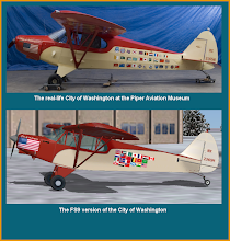
With a consecutive day of good weather I decided to launch for Presque Isle, Maine this afternoon. This leg was a tad longer (436 NM) than what I've done lately and of course sans GPS, but the scenery was great, and there were enough characteristic landmarks to help me verify my course. It was also an important point of arrival for this trip because it was here that Truman & Evans began their historic journey.
The magnetic rhumbline heading is 052, but the corrected heading with forecasted winds at 6000 (I would be flying at 7500) was 042. I left at 12:33 PM, climbed to 7500 and set my heading and waited for the first landmarks - everything looked good after 30 nm. Three hours later I discovered I was over Bethel, ME - I though I am glad to be here, but am about 9 NM west of course. The winds aloft must have been lighter than anticipated. I decided to maintain my course as the scenery was great and the rugged terrain of the Presidential Range Wilderness Area passed under my left wing, with lots of fingerling lakes to the east.
At 4:31 PM I picked up the Presque Isle VOR; it was about 23 degrees right of my current course and about 62 NM away. So I was still just a few miles left of course, maybe a tad more, but within reason. I homed in toward the VOR, making wind corrections as necessary until I saw the airport, and then turned into a long shallow base leg, and then final, and finally landed RWY 1, with only a slightly moderate left crosswind after 4 hours and 29 minutes of flight time. Fuel burn: 35 gallons (7.8 gallons (and $29.50) per hour).
Sunday, January 31, 2010
Subscribe to:
Post Comments (Atom)

No comments:
Post a Comment