Where lies the land to which the ship would go?
Far, far away is all her seamen know.
-- Arthur Hugh Clough
I've been thinking a lot about navigation lately. T&E had extra avionics installed in their planes, but it was still long before GPS was around. So what was it? Probably things like a radio ranging receiver, such as an ADF. With these a pilot could even tune an AM broadcast radio station (but usually a non-directional beacon or NDB) and use the ADF receiver to tell which direction it was located. Another type of navigational aid is the VOR, which is a high-frequency (up to about 30 MHz) radio ranging device.
As I think about my own journey, I consider the possibility that T&E may have had sextants on board but I wonder how often they were used. Probably seldom, since it appears that they were oriented at least well enough to be able to reach airfields for each leg of their journey.
Surely T&E used any instruments they could to help them navigate, but they relied as much on visual landmarks - rivers, hills, ponds and coastlines, as well as radio towers, cities, and buildings and so forth when they could. I'm not sure what they did for ocean crossings and for other longer legs when even radio aids were not around, or were unusable. I'm thinking they probably used rhumbline navigation.
The shortest distance between two points on a sphere is known as a great circle route. Interestingly, it not depicted as a straight line on a flat (or plane) map, but rather as a curve. The problem with flying a great circle is that the heading constantly changes. The practical solution has been known by sailors since at least the 1600s and is known as plane sailing, or rhumb line navigation.
Rhumb line navigation is especially appealing because the pilot has only to fly a constant course along the same bearing. For relatively short flights at mid latitudes it is almost the same as the great circle route, and is exactly the same at the equator. The difference increases in the high latitudes. For example, a rhumb line course around 60 degrees North latitude is about 8.5% longer than a great circle route. Obviously this would be problematic for especially long voyages.
The longest leg of their flight across the North Atlantic was from Greenland to Iceland, for a distance of 670 nautical miles (NM), with Narsasuaq at N62 and Reykjavik at N64. Assuming 9% error, would equate to about an extra 60 NM of flying. I will seriously consider using rhumb line navigation for some of the legs on my flight around the world, but first I will calculate the great circle route distance and rhumb line distance for each of those legs and share them with you here.
About Me
- Will Rogers
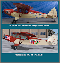
- Aviation enthusiast with more than 25 years experience in flight simulators, including more than 1800 hours logged on MSFS. Flying around the world in NX2365M, "The City of Washington".
No comments:
Post a Comment